


What is Maptitude?
Maptitude is a mapping program made by Caliper and it’s something we use a lot here at eXPD8 Analytics. In March, I went on a two-day course to update our team’s knowledge of the program. The course was brilliant. It was really interesting to see the different of companies which use Maptitude for such a wide range of things.
What do we use Maptitude for?
The main use-case for Maptitude is our Nearest DR Process, which we run each week to find the nearest member of staff to each store we plan to visit. This is essential due to the sheer number of different stores we visit over the whole of the UK.
If journeys aren’t optimised to reduce travel, this can add up to a huge amount of travel, with both environmental and financial implications. You can read our case study about how Maptitude helps the Nearest DR Process here: https://www.caliper.com/map-software/case-studies/expd8-maptitude.htm
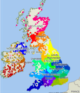
This is what the nearest DR map looks like. Each dot represents either a store we’re visiting or a member of staff.
Each time we schedule calls we run the Nearest DR process for the stores we intend to visit that scheduling period. This is then fed into the “Preferred DR” file for each region which allows Regional managers to assign calls to DRs, based on a combination of previous experience and travel distance.
This distance and time information is also used when ordering calls. After calls have been assigned by the regional managers, we run a sequencing process which orders calls to produce optimised journeys. This means that merchandisers don’t waste time and fuel on unnecessary back and forth trips, as they complete all calls in one area before moving onto the next.
The importance of automation
As Maptitude’s distance and travel time process is fairly automated we can run it every week. Without this we would be much more limited, potentially needing to assign specific stores to specific merchandisers, reducing the flexibility we can offer to clients and making it harder to find cover in cases of staff sickness or absence.
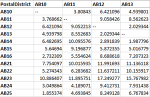
Here’s an example of the postcode database.
A recent personal project has been creating a database of the distance and travel time between every Postcode District. There are around 2857 postcode districts, resulting in just over 8 million journeys calculated! This now lives in our Datawarehouse and can be used for all kinds of travel related things. We’re working to have an even more extensive database, by calculating the distance between every postcode, however as there are around 1.8million postcodes in the UK this is a far larger undertaking!
Aiding the recruitment process
Maptitude also make the recruitment process easier, as we can map places where we’ve missed calls, to see if there are areas which may be struggling due to a lack of staff. We can also use the previously discussed database of postcode districts to see if any small vacancies are close enough together to be combined into a larger vacancy. This gives us the ability to hire fewer people, offer more hours and increases the quality of our hiring process.
Additionally, mapping areas where we have advertised vacancies makes understanding areas we need to recruit in and around much easier to picture. For example, if there is a particular area of the country in which we are taking longer able to fill vacancies, being able to see it on a map makes that issue much easier to understand and act upon.
We can also use Maptitude for regional planning and redistribution, to ensure that projected calls and hours are approximately balanced at a Regional and Zone Level. This helps to ensure an equal and manageable workload for our Regional and Zone managers. Maptitude has two different methods for territory mapping, one is automated, and one is more manual. Yet both allow one to balance regions upon a field: such as amount of calls, customers, members of staff or sales. The two processes can be used in conjunction, starting with the automated process and then manually adding in human initiative to tidy the regions up afterwards.
Advantages of using Maptitude
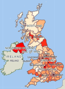
One of the great things about using Maptitude is how visual the output is. We get a lot of information to analyse and its often easier to convey outputs to people visually. Selection sets make it easy to colour code areas or points on a map. This is either to show the region they belong to, or more data specific information, such as whether positions are filled or vacant in that area. This can then inform strategies within the business.
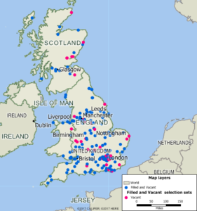
Example of filled and vacant positions in England and Scotland
Heatmaps are another way to visualise data. We can base the heat on any relevant information, such as showing the number of hours completed in each postcode area. This allows us to see how callage, that is to say the amount of time being spent on calls, is balanced around the country.
This heatmap shows the population around the country by postcode area, but we use the heatmaps for all kinds of data.
Another advantage of using Maptitude is the amount of data that its data layers contain. Data in Maptitude is organised into these layers, so postcode area is one layer, postcode, street, town, county etc. are others. And these layers contain census data such as population, age group information, % if people in work etc., which may be useful to an analysis. It also has a layer containing business information, like store locations and phone numbers, especially for lager UK chains, and another one containing points of interest such a tourist locations.
Challenges
One problem we often encounter is that the Republic of Ireland do not use postcodes. Eirecodes which were introduced in 2015 operate differently, with each home or business being given an individual code, meaning they can’t be used to locate areas in the same way. This is one of the reasons we use Geocodes to locate our staff and stores. Our geocodes are the first 7 digits of their longitude, followed by the first 8 of their latitude. When we need to locate staff or stores in Maptitude, we separate these back out into latitude and longitude and use these the plot locations. This is also helpful with new build areas whose postcodes may not be live yet.
How Maptitude can help you!
- Do you want to be able to visualise data on a map?
- Would you like to compare sales across the country?
- Do you want to build a new facility, but are unsure of the optimal location to reach the majority of your customer base?
- Do you have regions which need updating?
- Would you like to see how many of your customers live within 5, 10, 30 miles of your stores?
- Do you need to optimise journeys?
If the answer to any of these things is yes, then Maptitude can help you!
Aimee Barlow
Data Analyst